
BlindNav route calculation
This is a route planning web-service that allows the calculation of customized walking routes designed for visually impaired pedestrians. This service was developed as part of the BlindNav project, and is embedded in the BlindNav smartphone app (see below). The service is currently available in Israel, and is still under testing (for more details see Cohen and Dalyot, 2020).

POI visibility network
A QGIS plug-in that constructs graphs of unobstructed lines-of-sight between decision points and POIs for urban travel analysis. This plug-in was developed in cooperation with Dr. Asya Natapov (https://www.lboro.ac.uk/departments/abce/staff/asya-natapov/).
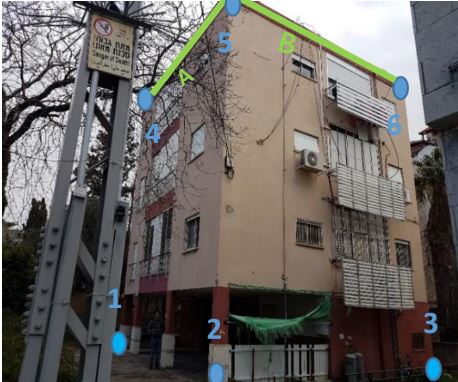
OpenStreetHeight
This is a smartphone application that allows the calculation of OSM building heights from a single photograph (for more details see Bshouty et al., 2020).
BlindNav
BlindNav is an accessible navigation smartphone app for visually impaired people, designed to plan accessible and safe walking routes and navigate the urban space (this app was developed as part of the BlindNav project).
https://play.google.com/store/apps/details?id=com.migdalor.walkrapp
UrbanCycler (TBD)
A multi-sided data-collection platform for public value creation. The app is designed to collect cycling travel trajectories, and embeds various gamification and community sustaining principals to ensure public engagement. It also integrates various functionalities and algorithms that ensure the collection of qualitative travel data. This app was developed as part of the BikeLonger project.

Migdalor tracker
This smartphone app is designed to collect walking routes regularly travelled by visually impaired pedestrians, and routes recommended by rehabilitation counselors. The routes are used for model training as part of the BlindNav project.
https://play.google.com/store/apps/details?id=com.migdalortracker